NOTE: This is a preliminary posting. Graphics to come around 4:30-5:00 PM today if possible.
This is crazy, but we are expecting snow tomorrow night and into Sunday!
The setup: An upper level disturbance crossing the west coast today will move into the Midwest tonight and tomorrow and through the Ohio Valley Saturday night and Sunday. This includes a piece of energy at 500 millibars known as a vort max, or vorticity maximum. That vort max provides the needed lift for precipitation.
The Storm Timeline: Snow will begin west to east during the evening hours of Saturday. Snow will be heaviest in the early hours of Sunday, then taper off west to east as the vort max passes Sunday.
Accumulation: Generally, we are looking at 1-3" of snowfall. One model was MUCH more aggressive and was painting 3 to as much as SIX inches! I don't buy that and am not going with it as of now. However, I do reserve the right to change my mind.
Impact: The bigger impact from the storm is likely Sunday morning. Expect slick roads, as the snow could come down heavy enough to cause a few issues.
Much more on this later including model maps to illustrate my points, but I did want to get the promised posting out there.
Friday, March 25, 2011
Wednesday, December 8, 2010
12Z Runs = GAME ON??
Well, this won't be as detailed as Monday night...mainly due to the fact that most every model has locked in to something close.
But, I want to detail somewhat what the models are showing, as far as our winter storm.
GFS: It's got the low EAST of the Appalachian Mountains. The 0c 850 line (remember from Monday that this is the freezing line at 5000 feet) is mostly along or SOUTH of the Ohio River. This indicates that at least the NW 2/3 of our area could see more snow than anything.
NAM: It's not quite in range. Low isn't so well defined, either.
UKMET (or United Kingdom Meteorological Office Model): It's too east. Low would track to near Baltimore and I just don't buy it. The Southeast Ridge is flat, but not THAT flat.
ECMWF: Garbage. Too far northwest for the pattern that is expected to be in place, which favors a track near or east of Cincinnati. Not buying it. It would be rain to very minor snow accumulation.
GGEM: Right over Cincinnati. Not favorable for heavy snow for Cincy proper, but it means a few inches on the back side.
JMA (Japanese Meteorological Agency): Haven't analyzed this in detail, but low over roughly, say, Paducah or maybe as far east as Evansville at 96 hours then one near Wilmington, DE at 120. Don't think it's the same low, possibly a coastal transfer and I'm not sure I buy it that far east. It'd give us rain to snow, several inches on back end. 500 thicknesses above 540 at 96 hours, crashing to 520-ish by 120 hours. HOWEVER, it could end up being a great setup - since the maps are in 24 hour increments, with a track over southern KY it could end up being a really good setup for somebody if not in the metro then just northwest of it.
BOTTOM LINE: It's still several days away. I want to see decent agreement before I make any calls as to snowfall amounts and/or icing potential (though the latter is becoming LESS likely). I expect everything to be fairly set in stone by Friday morning - at which point I can fine tune things and make a first call.
For now, however, the key points to know:
-- The storm currently looks to start as a mix or possibly plain rain, then switch over to snow late Saturday night or Sunday.
-- Winds will be a BIG problem...any location that gets heavy snow, WATCH OUT for potential blizzard conditions (which are NOT necessarily dependent on snow amounts).
-- Expect temperatures to CRASH, FAST Sunday. Could be in the lower 20s by evening and crashing to the single digits Monday morning!
-- SIGNIFICANT SNOW ACCUMULATIONS ARE POSSIBLE - It is too early to say where or how much - Monitor this space or the NKYWx Twitter page for information!
Tuesday, December 7, 2010
Developing Situation: Potential MONSTER Snow This Weekend.
NOTE: All GFS images are obtained from the NCEP website at http://www.nco.ncep.noaa.gov/.
I did say I wouldn't squawk about this until Wednesday - but I can't ignore the 0z GFS...
That model indicates a SIGNIFICANT SNOWSTORM for Cincinnati come this weekend.
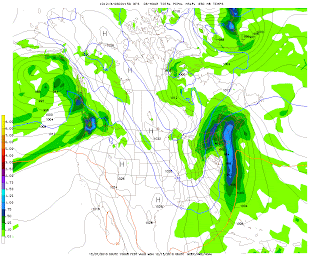
Here's the model at 126 hours (Click to enlarge...this will be the case for all of the images to follow, too):
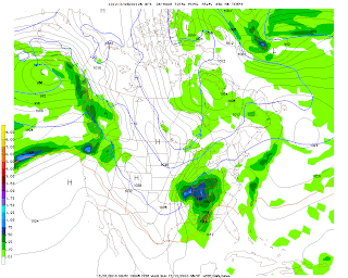
It depicts a low over Memphis, TN, measuring 996 millibars. Note the blue 0 line. That's the freezing level at about 5000 feet above earth. It's NORTH of us. Not precisely conducive to snow for Cincinnati, right? In fact this model indicates rain at this time.
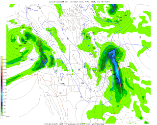
At 132 hours:
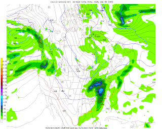
Note that the low has tracked to Nashville, TN, but is still 996 millibars. The 0 line is just outside Cincinnati to the south. Remember, that line being south favors snow.
At 138 hours:
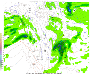
BULLSEYE. Notice the heaviest precipitation is DIRECTLY over Cincinnati. That would be 5-7.5" of snow in the previous 6 hours (from hour 132 to hour 138). The low has moved to roughly Bluefield, WV and has deepened to 992 millibars. Take note of the isobars (lines of equal pressure, which are labeled 992, 996, 1000, etc. on the map). Notice how tightly spaced they are...almost like a can of sardines, right? That indicates that winds will be strong out of the north. That 0 line is no problem - it's WAY south.
144 hours:
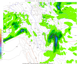
WOW. Look at the low, which in this image is now centered over southern PA. It's down to 984 millibars! That's strong...dropping 8 millibars over 6 hours. That, combined with the previous pressure drop from 996-992 means this storm is on its way to possible BOMBOGENESIS. The tri-state could still be seeing some light snow, up to an additional inch would accumulate.
I have to stop right here and answer a question likely on the mind of the reader. What is Bombogenesis? That is what happens when a storm experiences a rapid pressure drop of 24 millibars OR MORE in a 24 hour period. We went from 996 millibars to 984 millibars from 132 hours to 144 hours...so we're halfway there.
Just for kicks, let's look at 150 hours:
The low is now near Albany, NY...at 976 MILLIBARS! That's another 8 millibar pressure drop in six hours. Cincinnati is now out of any precipitation...but it's COLD.
And 156, just to see if we achieved a true meteorological "bomb":
Nope. We just missed it by 4 millibars. It's still 976 millibars, and has moved to the ME/Quebec border region. But...note that 0 line. WAYYYY down into FLORIDA. At this point, if any precipitation fell in, say, Jacksonville, or Atlanta...it'd be SNOW.
Now, a caution: We're still 5 days from the event. This is going to change. But right now...just know that a potential exists for SIGNIFICANT snowfall on Sunday that could impact your plans over the weekend, including any events you may plan to attend.
I did say I wouldn't squawk about this until Wednesday - but I can't ignore the 0z GFS...
That model indicates a SIGNIFICANT SNOWSTORM for Cincinnati come this weekend.
Here's the model at 126 hours (Click to enlarge...this will be the case for all of the images to follow, too):

It depicts a low over Memphis, TN, measuring 996 millibars. Note the blue 0 line. That's the freezing level at about 5000 feet above earth. It's NORTH of us. Not precisely conducive to snow for Cincinnati, right? In fact this model indicates rain at this time.
At 132 hours:

Note that the low has tracked to Nashville, TN, but is still 996 millibars. The 0 line is just outside Cincinnati to the south. Remember, that line being south favors snow.
At 138 hours:

BULLSEYE. Notice the heaviest precipitation is DIRECTLY over Cincinnati. That would be 5-7.5" of snow in the previous 6 hours (from hour 132 to hour 138). The low has moved to roughly Bluefield, WV and has deepened to 992 millibars. Take note of the isobars (lines of equal pressure, which are labeled 992, 996, 1000, etc. on the map). Notice how tightly spaced they are...almost like a can of sardines, right? That indicates that winds will be strong out of the north. That 0 line is no problem - it's WAY south.
144 hours:

WOW. Look at the low, which in this image is now centered over southern PA. It's down to 984 millibars! That's strong...dropping 8 millibars over 6 hours. That, combined with the previous pressure drop from 996-992 means this storm is on its way to possible BOMBOGENESIS. The tri-state could still be seeing some light snow, up to an additional inch would accumulate.
I have to stop right here and answer a question likely on the mind of the reader. What is Bombogenesis? That is what happens when a storm experiences a rapid pressure drop of 24 millibars OR MORE in a 24 hour period. We went from 996 millibars to 984 millibars from 132 hours to 144 hours...so we're halfway there.
Just for kicks, let's look at 150 hours:

The low is now near Albany, NY...at 976 MILLIBARS! That's another 8 millibar pressure drop in six hours. Cincinnati is now out of any precipitation...but it's COLD.
And 156, just to see if we achieved a true meteorological "bomb":

Nope. We just missed it by 4 millibars. It's still 976 millibars, and has moved to the ME/Quebec border region. But...note that 0 line. WAYYYY down into FLORIDA. At this point, if any precipitation fell in, say, Jacksonville, or Atlanta...it'd be SNOW.
Now, a caution: We're still 5 days from the event. This is going to change. But right now...just know that a potential exists for SIGNIFICANT snowfall on Sunday that could impact your plans over the weekend, including any events you may plan to attend.
Tuesday, October 26, 2010
Dangerous Day Today Across Greater Cincinnati
4:30 AM - CVG: 65°, Overcast
HIGH WIND WARNING 10 AM TO 8 PM TODAY FOR THE ENTIRE FORECAST AREA
Expect today to be a VERY DANGEROUS day across the Tri-State Area.
A HIGH WIND WARNING was issued just before 4 AM for the NWS Wilmington forecast area. The NWS says winds could gust upwards of 60 mph today, with damage likely.
As if that were not enough, we are also under a HIGH RISK (west) and MODERATE RISK (east) of severe thunderstorms today. The Storm Prediction Center says that a line of storms, currently to the west of St. Louis, will rake through the area around early afternoon. The line, and any storms that precede it, will be capable of any of the following:
-- Damaging winds, potentially upwards of 70 mph
-- Strong, potentially long-lived tornadoes
-- Hail upwards of 1" in diameter
Any storms should sweep east rapidly, and be gone by mid-evening. This front will usher in drier, cooler air - highs will not surpass 70 degrees after one final gasp tomorrow, at least for the next week, and possibly longer.
Because of the fluid situation, please follow me on Twitter at http://www.twitter.com/NKYWx for the very latest updates all day long, including any damage reports I receive.
Also, if you have pictures of damage in your area, you may either tweet them to me, or send them to the email address to the right of this blog post.
~Jeremy Moses
Sunday, October 10, 2010
HIGH FIRE DANGER Sunday
3:45 AM CVG 53°, Fair Skies
Good Sunday Morning,
A heightened fire danger exists for Sunday across the Tri-State area, as low relative humidity, combined with the current Severe Drought we're experiencing and highs that could approach a record of 89 degrees create dangerous fire conditions. (Interesting fact: Yesterday at 3 PM, the relative humidity was at 13...yes THIRTEEN percent - dewpoints were in the middle 30's with temperatures around 86°! Comfortable, yes - but dangerous for fires.) Remember, a few weeks ago several fires started in Indiana and Kentucky and at times got out of control...luckily, they didn't do major damage.
That fire danger may persist for parts of Kentucky on Monday, particularly near and SOUTH of Interstate 64. For Cincinnati, a cooler air mass begins to settle in, and humidities should increase as well. Unfortunately, this cooler air mass won't have much in the way of precipitation with it, in fact little to none. Also unfortunately, we don't see massive changes for at least the next week...I wish I had better news on that front but it doesn't look like there's any change, anytime soon.
Wednesday, September 15, 2010
One More Sunny, Hot Day - Then Stormy Thursday Night
5:55 AM CVG - 65°, Clear Skies
The heat that we've become accustomed to this summer (or so it seems) is back again today for one last stand. We'll hit a high of 88° under sunny skies.
Tonight will feature a chance of showers or storms sometime starting around 3:00 AM, with lows back down to around the 65° mark.
Things could get a bit hairy tomorrow. The computer models don't indicate a lot of instability, perhaps owing to the fact that we'll have rain around off and on much of the day. HOWEVER... the wind fields indicate 850 millibar (or 5000 foot AGL) level winds of around 64 mph, and 0-6 km shear around the same levels. The result would be severe thunderstorms, conditional on how unstable things get in the atmosphere and how warm we get, with winds being the primary threat.
Whether we get severe storms, we still may see wind gusts to 35 mph outside of any storms. This will be enough to inconvenience you if you're out walking so keep that in mind. (We'll update this situation tomorrow morning, especially if anything changes.) It should NOT, as it appears now, be enough to need a Wind Advisory, much less a High Wind Watch/Warning, but we'll keep our eyes on it. (The windstorm of 2008, which is just 2 years ago yesterday [9/14], should have taught meteorologists across the area to prepare for ANYTHING.) Only one model (the North American Mesoscale) has anything stronger right now.
After that, look for a MUCH better weekend. Even as a front develops to our north, high pressure to our south should keep it and its effects up there, and away from the Cincinnati Tri-State area.
Don't forget to follow me on Twitter: http://www.twitter.com/NKYWx
~Jeremy Moses
Sunday, July 25, 2010
One More Night of Heat - Storms Later
3:20 AM CVG: 82°, HEAT INDEX 87°
You're not mis-reading that above observation. At 3 AM Eastern Time Cincinnati is still above 80 degrees. Last night, if you recall, I said it didn't get below 80 until nearly 1 in the morning.
We'll probably stay near 80, or above, until sometime around 5-7 AM (the exception: If you get under a brief shower, you might just cool off a few degrees and drop below that 80 degree mark). Showers and storms will move in from the west and northwest. These are in association with what is really more of a "wind shift line" than a "cold front". Yes, the temperatures will drop behind this - but only for maybe a day. The main effect is that winds will go from the southwest to the northeast. Even that won't last as winds will quickly back around to the southeast again by Monday night into Tuesday.
Keep an eye on these storms today - they will have the potential of producing heavy rainfall and, if they are delayed for very long OR we get a break in activity, possibly being severe with damaging winds being the biggest threat. We'll have our eyes on the situation throughout the day.
~Jeremy Moses
@NKYWx on Twitter.com
PS: There may be some confusion as to why an Excessive Heat Warning was issued by the Weather Service for Cincinnati and Dayton proper - but only Heat Advisories for the other counties of the warning area.
Here's the explanation. Wilmington's policy is as follows for Excessive Heat Warnings versus Heat Advisories:
Heat Advisory:
All Zones: When the heat index values range between 100-104 degrees.
Excessive Heat Warning:
Outside the cities of Cincinnati and Dayton: Anytime the heat index reaches past 105 degrees.
In Cincinnati and Dayton, specifically for Hamilton and Montgomery Counties: Either the above OR if heat index values of 100-104 persist for a second consecutive day or more.
As yesterday was the second day of 100-104 degree heat index values in Cincinnati and Dayton themselves, that triggered local Excessive Heat Warning criteria. Due to the criteria being more strict outside those two cities, a warning wasn't called. However I do have reports that a few areas *MAY* have breached those criteria a time or two.
Subscribe to:
Posts (Atom)