Well, this won't be as detailed as Monday night...mainly due to the fact that most every model has locked in to something close.
But, I want to detail somewhat what the models are showing, as far as our winter storm.
GFS: It's got the low EAST of the Appalachian Mountains. The 0c 850 line (remember from Monday that this is the freezing line at 5000 feet) is mostly along or SOUTH of the Ohio River. This indicates that at least the NW 2/3 of our area could see more snow than anything.
NAM: It's not quite in range. Low isn't so well defined, either.
UKMET (or United Kingdom Meteorological Office Model): It's too east. Low would track to near Baltimore and I just don't buy it. The Southeast Ridge is flat, but not THAT flat.
ECMWF: Garbage. Too far northwest for the pattern that is expected to be in place, which favors a track near or east of Cincinnati. Not buying it. It would be rain to very minor snow accumulation.
GGEM: Right over Cincinnati. Not favorable for heavy snow for Cincy proper, but it means a few inches on the back side.
JMA (Japanese Meteorological Agency): Haven't analyzed this in detail, but low over roughly, say, Paducah or maybe as far east as Evansville at 96 hours then one near Wilmington, DE at 120. Don't think it's the same low, possibly a coastal transfer and I'm not sure I buy it that far east. It'd give us rain to snow, several inches on back end. 500 thicknesses above 540 at 96 hours, crashing to 520-ish by 120 hours. HOWEVER, it could end up being a great setup - since the maps are in 24 hour increments, with a track over southern KY it could end up being a really good setup for somebody if not in the metro then just northwest of it.
BOTTOM LINE: It's still several days away. I want to see decent agreement before I make any calls as to snowfall amounts and/or icing potential (though the latter is becoming LESS likely). I expect everything to be fairly set in stone by Friday morning - at which point I can fine tune things and make a first call.
For now, however, the key points to know:
-- The storm currently looks to start as a mix or possibly plain rain, then switch over to snow late Saturday night or Sunday.
-- Winds will be a BIG problem...any location that gets heavy snow, WATCH OUT for potential blizzard conditions (which are NOT necessarily dependent on snow amounts).
-- Expect temperatures to CRASH, FAST Sunday. Could be in the lower 20s by evening and crashing to the single digits Monday morning!
-- SIGNIFICANT SNOW ACCUMULATIONS ARE POSSIBLE - It is too early to say where or how much - Monitor this space or the NKYWx Twitter page for information!
Wednesday, December 8, 2010
Tuesday, December 7, 2010
Developing Situation: Potential MONSTER Snow This Weekend.
NOTE: All GFS images are obtained from the NCEP website at http://www.nco.ncep.noaa.gov/.
I did say I wouldn't squawk about this until Wednesday - but I can't ignore the 0z GFS...
That model indicates a SIGNIFICANT SNOWSTORM for Cincinnati come this weekend.
Here's the model at 126 hours (Click to enlarge...this will be the case for all of the images to follow, too):
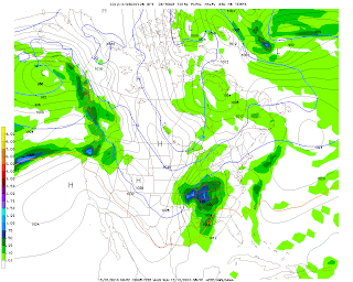
It depicts a low over Memphis, TN, measuring 996 millibars. Note the blue 0 line. That's the freezing level at about 5000 feet above earth. It's NORTH of us. Not precisely conducive to snow for Cincinnati, right? In fact this model indicates rain at this time.
At 132 hours:
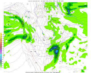
Note that the low has tracked to Nashville, TN, but is still 996 millibars. The 0 line is just outside Cincinnati to the south. Remember, that line being south favors snow.
At 138 hours:
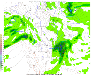
BULLSEYE. Notice the heaviest precipitation is DIRECTLY over Cincinnati. That would be 5-7.5" of snow in the previous 6 hours (from hour 132 to hour 138). The low has moved to roughly Bluefield, WV and has deepened to 992 millibars. Take note of the isobars (lines of equal pressure, which are labeled 992, 996, 1000, etc. on the map). Notice how tightly spaced they are...almost like a can of sardines, right? That indicates that winds will be strong out of the north. That 0 line is no problem - it's WAY south.
144 hours:
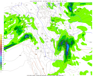
WOW. Look at the low, which in this image is now centered over southern PA. It's down to 984 millibars! That's strong...dropping 8 millibars over 6 hours. That, combined with the previous pressure drop from 996-992 means this storm is on its way to possible BOMBOGENESIS. The tri-state could still be seeing some light snow, up to an additional inch would accumulate.
I have to stop right here and answer a question likely on the mind of the reader. What is Bombogenesis? That is what happens when a storm experiences a rapid pressure drop of 24 millibars OR MORE in a 24 hour period. We went from 996 millibars to 984 millibars from 132 hours to 144 hours...so we're halfway there.
Just for kicks, let's look at 150 hours:
The low is now near Albany, NY...at 976 MILLIBARS! That's another 8 millibar pressure drop in six hours. Cincinnati is now out of any precipitation...but it's COLD.
And 156, just to see if we achieved a true meteorological "bomb":
Nope. We just missed it by 4 millibars. It's still 976 millibars, and has moved to the ME/Quebec border region. But...note that 0 line. WAYYYY down into FLORIDA. At this point, if any precipitation fell in, say, Jacksonville, or Atlanta...it'd be SNOW.
Now, a caution: We're still 5 days from the event. This is going to change. But right now...just know that a potential exists for SIGNIFICANT snowfall on Sunday that could impact your plans over the weekend, including any events you may plan to attend.
I did say I wouldn't squawk about this until Wednesday - but I can't ignore the 0z GFS...
That model indicates a SIGNIFICANT SNOWSTORM for Cincinnati come this weekend.
Here's the model at 126 hours (Click to enlarge...this will be the case for all of the images to follow, too):

It depicts a low over Memphis, TN, measuring 996 millibars. Note the blue 0 line. That's the freezing level at about 5000 feet above earth. It's NORTH of us. Not precisely conducive to snow for Cincinnati, right? In fact this model indicates rain at this time.
At 132 hours:

Note that the low has tracked to Nashville, TN, but is still 996 millibars. The 0 line is just outside Cincinnati to the south. Remember, that line being south favors snow.
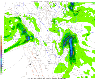
At 138 hours:

BULLSEYE. Notice the heaviest precipitation is DIRECTLY over Cincinnati. That would be 5-7.5" of snow in the previous 6 hours (from hour 132 to hour 138). The low has moved to roughly Bluefield, WV and has deepened to 992 millibars. Take note of the isobars (lines of equal pressure, which are labeled 992, 996, 1000, etc. on the map). Notice how tightly spaced they are...almost like a can of sardines, right? That indicates that winds will be strong out of the north. That 0 line is no problem - it's WAY south.
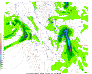
144 hours:

WOW. Look at the low, which in this image is now centered over southern PA. It's down to 984 millibars! That's strong...dropping 8 millibars over 6 hours. That, combined with the previous pressure drop from 996-992 means this storm is on its way to possible BOMBOGENESIS. The tri-state could still be seeing some light snow, up to an additional inch would accumulate.
I have to stop right here and answer a question likely on the mind of the reader. What is Bombogenesis? That is what happens when a storm experiences a rapid pressure drop of 24 millibars OR MORE in a 24 hour period. We went from 996 millibars to 984 millibars from 132 hours to 144 hours...so we're halfway there.
Just for kicks, let's look at 150 hours:

The low is now near Albany, NY...at 976 MILLIBARS! That's another 8 millibar pressure drop in six hours. Cincinnati is now out of any precipitation...but it's COLD.
And 156, just to see if we achieved a true meteorological "bomb":

Nope. We just missed it by 4 millibars. It's still 976 millibars, and has moved to the ME/Quebec border region. But...note that 0 line. WAYYYY down into FLORIDA. At this point, if any precipitation fell in, say, Jacksonville, or Atlanta...it'd be SNOW.
Now, a caution: We're still 5 days from the event. This is going to change. But right now...just know that a potential exists for SIGNIFICANT snowfall on Sunday that could impact your plans over the weekend, including any events you may plan to attend.
Subscribe to:
Posts (Atom)